
Between Monday 6 and Thursday 9 July 2026, a frontal system strengthened by a category 3-4 atmospheric river delivered intense rainfall across La Araucanía, Los Ríos and Los Lagos ² ³ . The combination of abundant Pacific moisture, strong winds and a freezing level above 3,000 m substantially increased the hydrological hazard ⁴ .
The effects became visible within hours: flooding and waterlogging, landslides, road closures, damaged homes, power cuts and the closure of border crossings ² . Chile’s National Service for Disaster Prevention and Response (Senapred) maintained a Yellow Alert across all three regions throughout the episode ⁴ . In its 9 July balance, Senapred reported 20 disaster-affected people, 64 isolated people, 3 destroyed homes, 4 homes with major damage, 48 with minor damage and 50 still under evaluation in La Araucanía and Los Ríos; the report did not record fatalities or provide a monetary estimate of economic losses ⁶ .
The decisive factor was not simply the total rainfall. At several stations, more than 65% of the event total fell within a single day. This temporal concentration, combined with the high freezing level and progressively wetter soils, favoured rapid responses in rivers, streams, gullies and hillslopes.
The central figure: up to 200 mm of accumulated rainfall
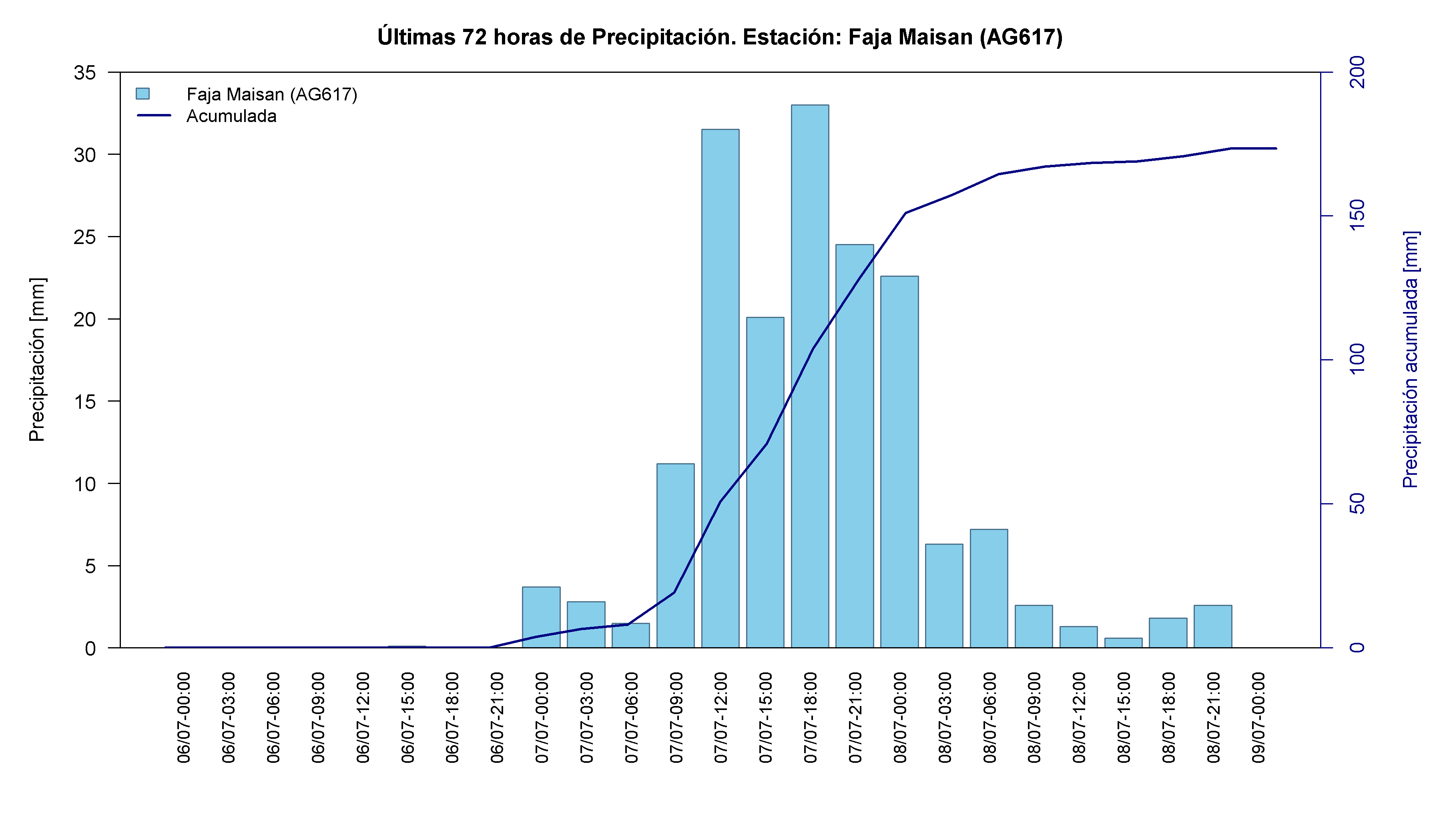
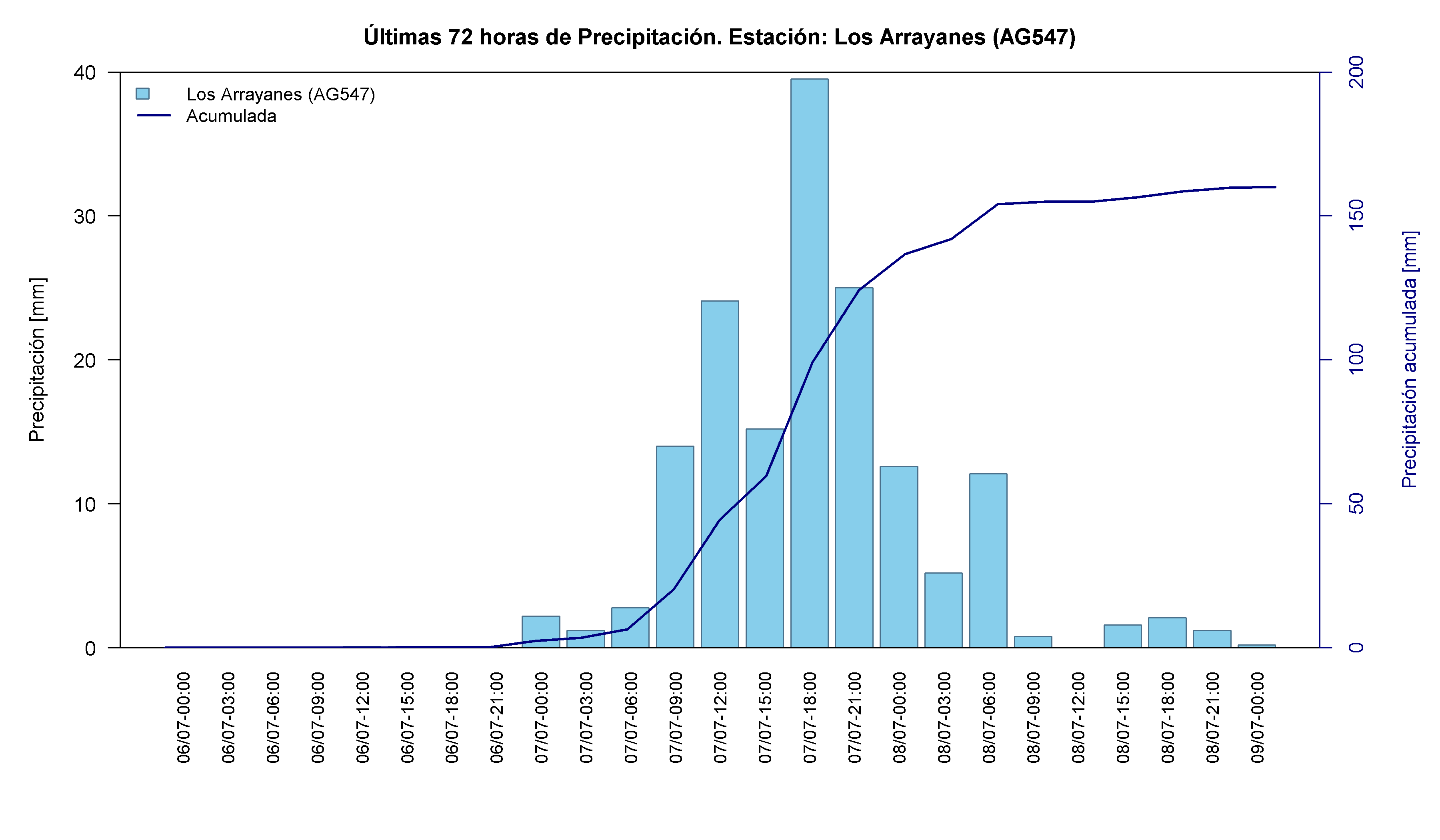
According to figures released by Senapred, mean rainfall across the three most affected regions reached 180 mm ¹ . Some stations recorded still higher totals: Estación Experimental Austral in Los Ríos accumulated 200 mm; Mariquina, also in Los Ríos, 191.8 mm; Faja Maisan in La Araucanía, 173.4 mm; Huacamapu in Los Lagos, 160.4 mm; and Los Arrayanes in La Araucanía, 160 mm ⁵ .
This was not merely a large amount of rainfall, but a large amount delivered over a short period. At several stations, a dominant share of the event total accumulated within a window of only 24 to 36 hours ⁵ . When rain arrives this quickly, there is less time for water to infiltrate, be stored temporarily on the land surface or be conveyed safely through the drainage network.
The resulting impacts included overtopping watercourses, slope failures, landslides and road disruption ¹ . Undersecretary of the Interior Máximo Pavez confirmed that national emergency coordination had been activated, although the government ruled out declaring a constitutional state of emergency ¹ . In Senapred’s 9 July balance, 19,633 customers remained without electricity across the corridor from the Metropolitan Region to Los Lagos ⁶ .
The weather conditions also prompted the precautionary closure of the Pino Hachado and Samoré border crossings and the Peulla Border Complex ¹ .
What is an atmospheric river?
An atmospheric river is a long, relatively narrow corridor in the atmosphere that transports large quantities of water vapour from the ocean towards land. When this moisture interacts with a frontal system and mountainous terrain, it can condense and generate persistent, intense rainfall.
In southern Chile, both the Coastal Range and the Andes force moist air to rise. This orographic lifting cools the air mass and favours precipitation. During the 6-9 July episode, the atmospheric river acted as a sustained moisture supply directed towards south-central and southern Chile ² ³ .
A category 3-4 classification describes an event ranging from strong to intense. The atmospheric category alone, however, does not determine the damage. Impacts also depend on duration, rainfall intensity, antecedent soil moisture, river levels, topography and the exposure of homes and infrastructure ³ .
Why the freezing level mattered
The freezing level is the approximate altitude at which air temperature reaches 0 °C. Below this level, precipitation generally falls as rain; above it, snow is more likely, although the actual transition depends on the full vertical temperature profile and other atmospheric conditions.
During this storm, the freezing level was above 3,000 m ⁴ . This extended the rain-affected area to high elevations, including Andean and foothill zones where, under colder winter conditions, part of the precipitation would have been stored temporarily as snow ² .
Rainfall produces runoff more rapidly than newly accumulated snow. A high freezing level can therefore increase the amount of water reaching rivers and streams during the event itself. Where an existing snowpack is present, rain and warmer air may also accelerate snowmelt and further strengthen the hydrological response. Together, these processes increase the risk of rapid rises in discharge, erosion, gully activation and landslides ² ⁴ .
Three frontal systems over increasingly wet ground
According to the Chilean Meteorological Directorate (DMC), the episode formed part of a sequence of three frontal systems ⁴ . Meteorologist Elio Brufort reported that coastal stations in La Araucanía and Los Ríos had already recorded 110-120 mm during the first half of the week, with a further 40-80 mm still expected across both regions ⁴ .
The second, weaker frontal system mainly affected Los Ríos and Los Lagos. The third progressed into south-central Chile, with its strongest influence in Maule and Ñuble, while also producing rainfall over mountain areas from Valparaíso to Los Lagos ⁴ .
This succession matters because catchment response depends on initial conditions. Each new rainfall pulse encountered wetter soils, less available surface storage and already elevated watercourses. Under such conditions, a larger proportion of additional rainfall can be converted rapidly into runoff.
Main impacts of the storm
Authorities maintained a Yellow Alert in La Araucanía, Los Ríos and Los Lagos throughout the event ⁴ . Reported impacts included:
- 20 disaster-affected people and 64 isolated people in La Araucanía and Los Ríos ⁶ ;
- 3 destroyed homes, 4 with major damage, 48 with minor damage and 50 still under evaluation ⁶ ;
- electricity outages, with 19,633 customers without service between the Metropolitan Region and Los Lagos in the 9 July balance ⁶ ;
- road disruption and material sliding onto transport routes ² ⁴ ;
- precautionary closure of the Pino Hachado and Samoré border crossings and the Peulla Border Complex ¹ ;
- landslides in coastal and Andean foothill areas ¹ ⁴ ;
- homes affected by the ingress of water or mud ¹ ² ⁶ ;
- suspension of maritime connections serving Corral ¹ ;
- rapid rises in rivers, streams and gullies ¹ ² .
Regional report
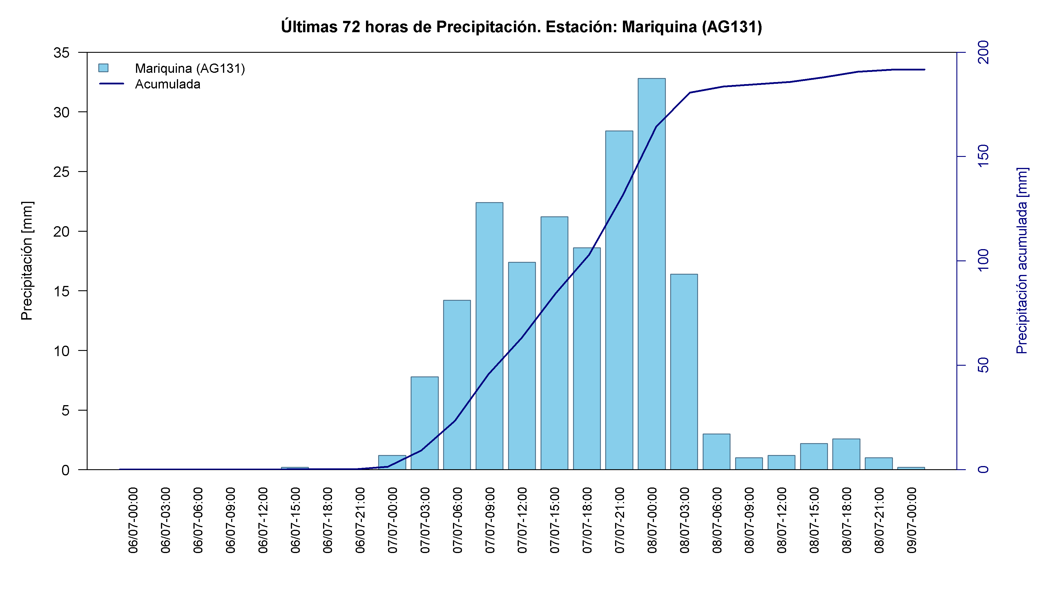
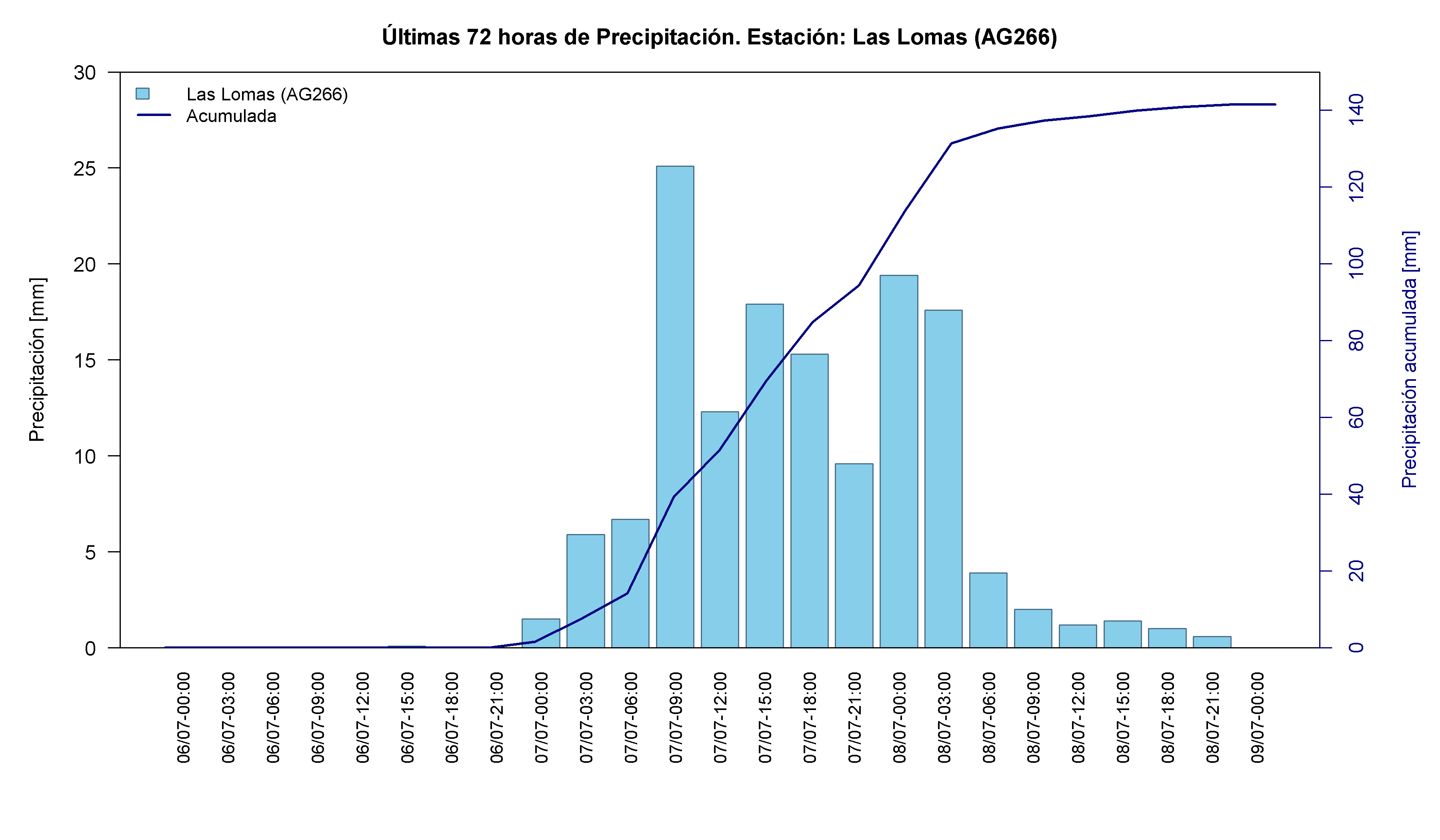
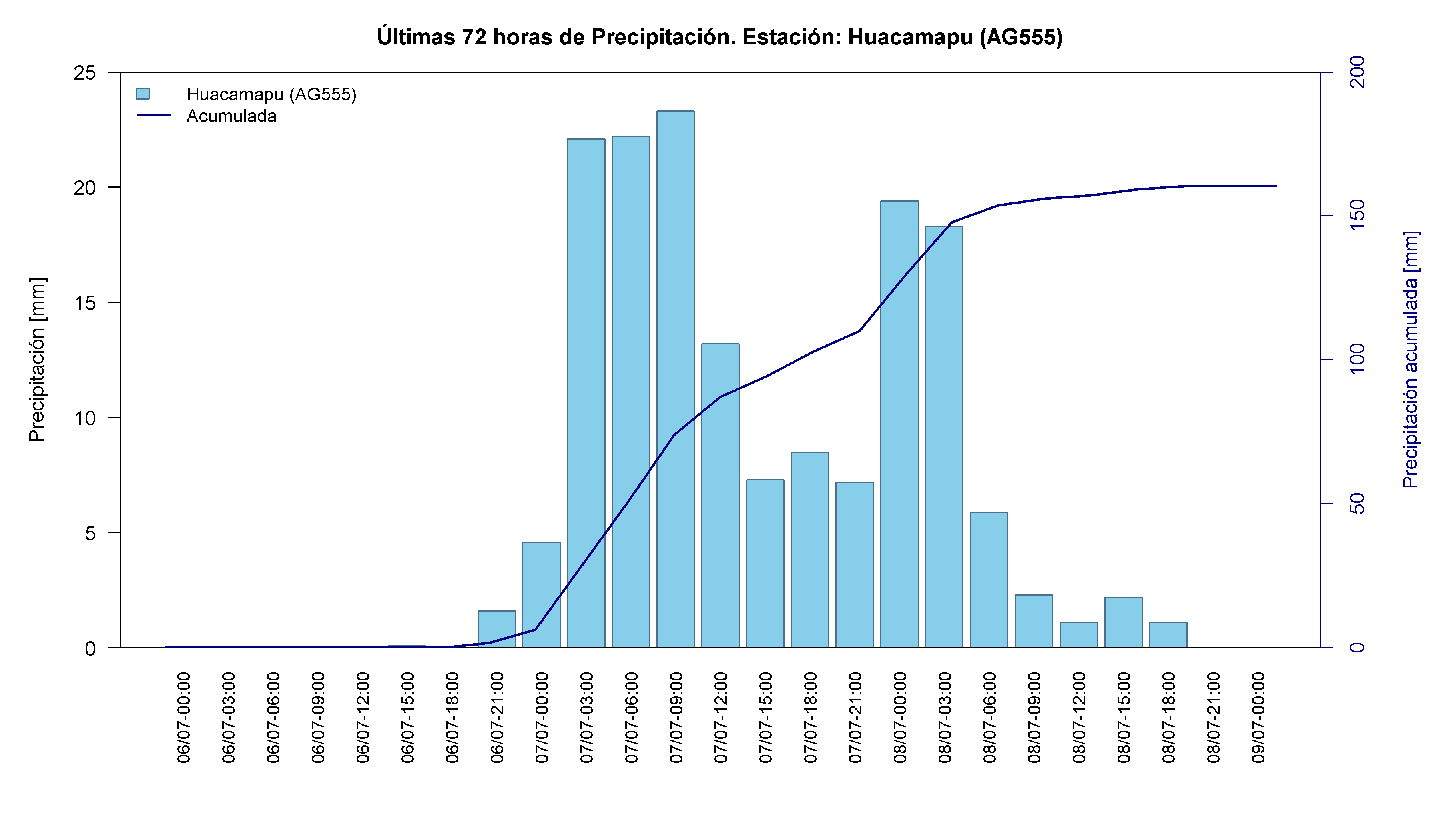
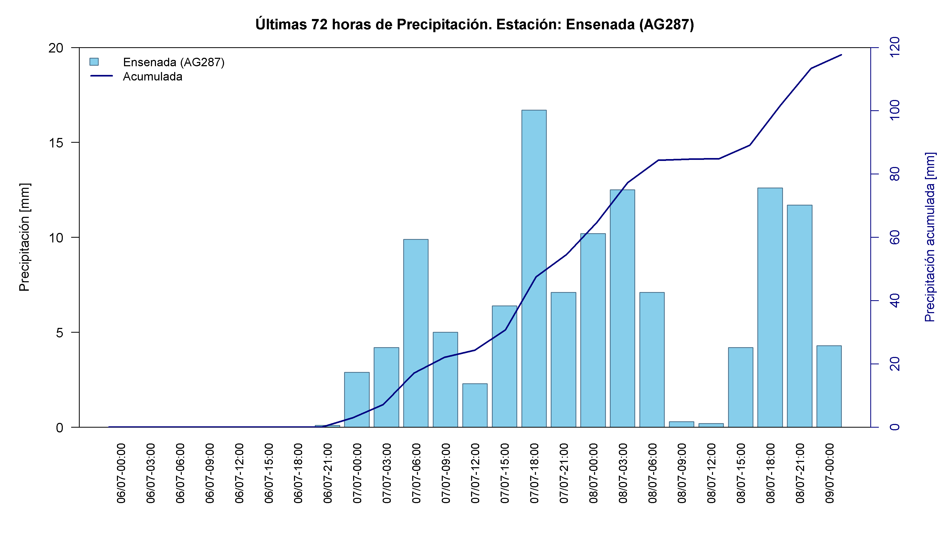
The following records show daily and accumulated rainfall reported by gauges in each region during the event, using data from the Visualizador Meteorológico (VisMet) ⁵ .
Figure 1. Location map and information for rainfall stations in La Araucanía, Los Ríos and Los Lagos during the event.
Los Ríos Region: Corral at the centre of the impacts
Corral was among the worst-affected municipalities. Ground failure in the Chacabuco sector and rising water in the San Juan River sent mud into several homes and cut sections of road ⁴ . Daniel Epprecht, Senapred’s regional director for Los Ríos, reported minor damage to a group of homes and impacts on vehicles, warning that the number of damaged properties could rise while heavy rainfall continued ⁴ .
Pilar Reyes, who lives near the mouth of the Valdivia River, described the event as unprecedented for local residents and said that strong winds and rising water prevented them from leaving their homes ¹ . Corral’s mayor, Claudio González, reported several landslides of varying magnitude in El Boldo and confirmed the suspension of maritime connectivity to the municipality ¹ .
A La Tercera report described Corral as the storm’s epicentre and summarized severe local damage: Route T-400 disruption from landslides, a debris flow in the Yerbas Buenas gully, one destroyed home and 19 homes under evaluation, collapses in La Aguada, Postal and La Rama, overflowing streams and a sinkhole ⁷ .
Table 1. Accumulated rainfall recorded at gauges in the Los Ríos Region between 6 and 9 July 2026. Source: Authors’ analysis based on data from the Visualizador Meteorológico (VisMet) .
The highest regional totals occurred at Estación Experimental Austral (200 mm), Mariquina (191.8 mm) and Las Lomas (141.5 mm). All three show a similar pattern: almost no rainfall on Monday 6 July, a pronounced maximum on Tuesday 7, a second day of moderate rainfall on Wednesday 8 and little or no rain on Thursday 9.
Tuesday 7 July contributed more than 65% of the event total at each station. Much of the hydrological pressure was therefore concentrated within a window of approximately 24 to 36 hours.

Los Lagos Region: landslides and disruption on key roads
In Petrohué, landslides kept Route CH-225, which links Puerto Montt and Ensenada, closed at La Ventana and La Máquina ² ⁴ . An overflowing stream was also reported in San Juan de la Costa ¹ .
Table 2. Accumulated rainfall recorded at gauges in the Los Lagos Region between 6 and 9 July 2026. Source: Authors’ analysis based on data from the Visualizador Meteorológico (VisMet) .
Huacamapu (160.4 mm) and Ensenada (117.7 mm) recorded the highest totals in the region. Huacamapu reproduced the dominant event pattern: 108.4 mm on Tuesday 7 July, more than 65% of its total, followed by a clear decline on Wednesday 8.
Ensenada showed a more even distribution between Tuesday 7 (54.5 mm) and Wednesday 8 (58.8 mm), with the latter producing its daily maximum. It was also the only highlighted station still receiving appreciable rainfall on Thursday 9 (4.3 mm), consistent with the later persistence of precipitation in this more southerly area.
La Araucanía Region: flooding and intense coastal rainfall
Toltén experienced substantial flooding and waterlogging in communities including Queule and Villa Los Boldos, placing homes near the Queule gully at risk ⁴ . Water also entered homes in Hualpín ² .
In Pucón, 155 mm of rainfall affected 17 homes and led to three people requiring temporary accommodation. The municipality maintained continuous river-flow monitoring in coordination with Curarrehue ¹ . Villarrica also experienced waterlogging and an overflowing canal, although rainfall intensity began to diminish towards the end of the episode ¹ .
Table 3. Accumulated rainfall recorded at gauges in the La Araucanía Region between 6 and 9 July 2026. Source: Authors’ analysis based on data from the Visualizador Meteorológico (VisMet) .
Faja Maisan (173.4 mm) and Los Arrayanes (160 mm) recorded the region’s highest event totals. Both stations received almost no rainfall on Monday 6 July and concentrated more than 70% of their totals on Tuesday 7. Rainfall then declined markedly on Wednesday 8 and was residual or absent on Thursday 9.
Both gauges are in the coastal sector, consistent with DMC reports that the largest totals during this phase were concentrated at coastal stations in La Araucanía and Los Ríos ⁴ .
What this event reveals about extreme-rainfall risk
Storm hazard depends on more than the accumulated total. The location, intensity and duration of the rainfall, together with antecedent catchment conditions, all shape the outcome. Three factors amplified the risk during this event:
- Strong temporal concentration: at the wettest stations, more than 65% of total event rainfall fell on Tuesday 7 July ⁵ .
- A high freezing level: above 3,000 m, this increased the mountain area receiving rain rather than snow and accelerated the transfer of water towards rivers and streams ⁴ .
- Increasing antecedent wetness: the sequence of frontal systems progressively reduced available soil storage and favoured faster catchment responses ⁴ .
These mechanisms explain why the same meteorological system can produce very different effects in nearby places. Topography, soil conditions, drainage capacity, vegetation cover, occupation of hillslopes and river margins, and the vulnerability of infrastructure all shape the final impact.
The episode also demonstrates the need to combine weather forecasts with hydrological and territorial information. Knowing how much rain is expected is necessary but insufficient. Anticipating impacts requires information on where rainfall will be concentrated, how wet the catchments already are and which exposed assets lie downstream or on unstable terrain.
Advice for exposed communities
Even after rainfall has weakened, danger may persist for hours or days because of elevated river levels, saturated soils and unstable hillslopes. Senapred and the DMC advise people to:
- avoid unnecessary travel through affected areas;
- never cross flooded roads, even when the water appears shallow;
- keep away from swollen rivers, streams and gullies;
- avoid slopes showing cracks, falling material or muddy runoff;
- follow official information from Senapred, the DMC and local authorities;
- identify alternative routes and safe locations in advance.
Exposure is also unevenly distributed. Homes near rivers, gullies, cut slopes and rural roads often experience the effects of extreme rainfall first, as occurred in Corral, Petrohué and Toltén during this episode.
Frequently asked questions
What made this storm unusually damaging?
It combined a strong-to-intense atmospheric river, rainfall concentrated within a short period, a freezing level above 3,000 m and a sequence of frontal systems falling on progressively wetter ground.
Why does a high freezing level increase flood risk?
It expands the area receiving rain rather than snow. Liquid water can reach the drainage network more rapidly and, where a snowpack is already present, rainfall and warmer air can also contribute to snowmelt.
Did every station receive its heaviest rainfall on the same day?
No. Most highlighted stations reached their daily maximum on Tuesday 7 July, but Ensenada peaked on Wednesday 8. This difference reflects the spatial and temporal progression of the weather system.
Does a large rainfall total always cause severe damage?
Not necessarily. Impacts depend on intensity, duration, antecedent soil moisture, slope, drainage capacity and the exposure of people and infrastructure. Large totals delivered over a short period nevertheless increase the likelihood of damaging outcomes.
[5]: Rainfall data: Visualizador Meteorológico (VisMet)
[6]: Avanzan tareas de rehabilitación en zonas afectadas por el sistema frontal - SENAPRED